
Downloading Sentinel-2 data
Sentinel-2 data is online for quite a while and now we would like to have a deeper look into how to get the L1C data. According to the tiling scheme discussed in the previous post, there are about 22,000 tiles covering the land masses as well as smaller seas. One full coverage of the Earth will consume storage size of about 3 Terabytes. Considering that each of the two Sentinel-2 satellites has a revisiting time of ten days, we will get a full coverage every five days. This is a lot of data and you probably won't need all of it.
Hence, there are various tools to find the data you need.
# ScienceHub
The Sentinel Scientific Data Hub (opens new window) or SciHub is the main public access point maintained by ESA. You will need to register before using it. There are two ways to get data from the ScienceHub via
- the DHUS GUI (opens new window) and
- the API (opens new window).
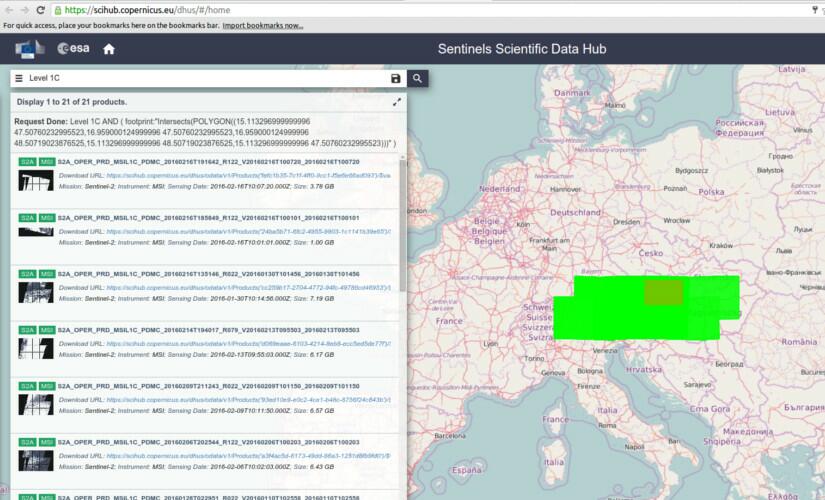
Using DHUS is quite straight forward, as other (opens new window) blogs already pointed out. Just draw an area of interest, type your search term like "level 1C" in the box and hit enter.
Well, maybe it's not that straight forward after all, as "L1C" shows no results and "Level 1 C" selects Sentinel 1 data; so make sure you provide DHUS with the string it can work with (i.e. "level 1C").
You'll see the search results in form of footprints on a map and as a list of products on the left side. You then can inspect the metadata, browse images of the selected products and finally download the data.
The search results are sorted by date, listing the most recent data first. The list also shows small thumbnails on the left. We chose to download this product (opens new window) which covers Vienna on a beautiful day in early February. Data size is 6.4GB so make sure to get a cup of coffee (or two) while downloading. After finishing the coffee you may probably realize the download failed. As ScienceHub is the only "open" access point for the general public maintained by ESA, there are many users accessing the data there and as Sentinel 2 data products are quite high volume, due to the 10m optical resolution, capacities are often exhausted.
Apart from DHUS GUI there is also a DHUS-API (opens new window) which allows programmatic access to the API's search and download functions. In addition, there are also already other tools published, [Sentinel-download](https://github.com/olivierhagolle/Sentinel-download), [esa_sentinel](https://github.com/jonas-eberle/esa_sentinel), and [sentinelsat](https://github.com/ibamacsr/sentinelsat), which facilitate working with the API from e.g. a Python script or via the command line.
We will give [sentinelsat](https://github.com/ibamacsr/sentinelsat) a try. It works on command line and provides a Python API as wel,l which makes it easy to integrate with your infrastructure.
Once sentinelsat is installed and you have a GeoJSON containing your Area of Interest (opens new window), you can search and download products from the command line:
sentinel search --sentinel2 -s 20160201 -e 20160211 guest guest vienna\_bbox.geojson
This returns the following output:
sentinel download --md5 guest guest a3f4ac5d-6173-49dd-86a3-1251d8fb9fd0
Of course it will take a while to download the 6.4 GB of data, but with these two commands you managed to both query and retrieve a Sentinel-2 product.
Now, lets have a look what this product looks like using the visible bands:
Interactive viewer provided by © mapalupa.com (opens new window)
# Sinergise and AWS
A Slovenian company called Sinergise (opens new window) courageously took the first leap and uploads the Sentinel-2 archive to an Amazon AWS (opens new window). That's right, now there is not only Landsat 8 imagery (opens new window) available but also Sentinel-2.
The data in the bucket (opens new window) is structured by a MGRS-like Sentinel tiling scheme instead of Sentinel data products.
If we take a closer look on our example product, we see it contains data from multiple Sentinel tiles:
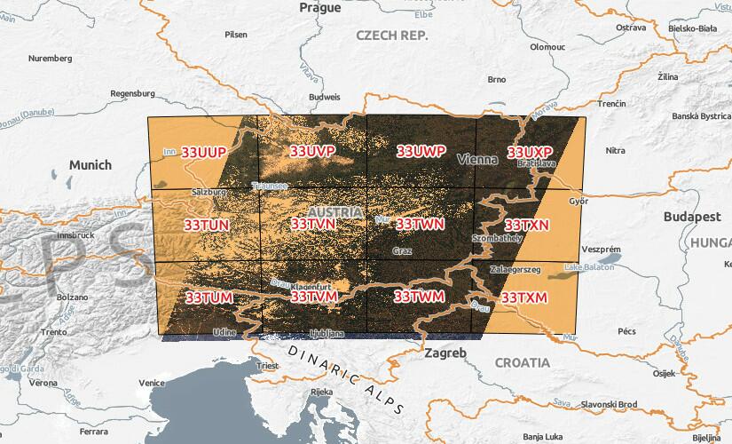
The overlap you can see at the southern image border is intended and done automatically while creating the product. If you want to download the data from Amazon, you will have to follow the data structure described here (opens new window).
The URL to the tile containing Vienna (33UWP (opens new window)) looks like this:
This introduction should help you making the first steps to use the Sentinel-2 data offered by ESA. In the upcoming next Sentinel post, we will have a deeper look into the SAFE data structure and image formats used by the Sentinels. So stay tuned.