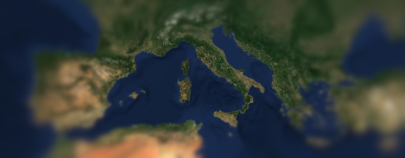
Sentinel-2 cloudless 2022
Introducing the latest marvel in Earth observation: Sentinel-2 Cloudless, the pinnacle of usability clarity in satellite imagery. This newest version takes your visual exploration to unprecedented heights, delivering pristine, cloud-free views of our planet with breathtaking detail and accuracy. Every pixel tells a story as Sentinel-2 Cloudless unveils the Earth's beauty in vibrant colors, making it an indispensable tool for scientists, environmentalists, urban planners, and explorers alike. Immerse yourself in landscapes and cityscapes like never before, with crystal-clear rivers, lush forests, and sprawling metropolises, all devoid of those pesky clouds that once obscured your view. Whether you're monitoring environmental changes, studying land use, or simply marveling at the Earth's wonders, Sentinel-2 Cloudless is your passport to a world of visual splendor. Don't miss your chance to witness our planet in its most unobstructed glory—upgrade to Sentinel-2 Cloudless today!
We now finally announce this year's latest release, Sentinel-2 cloudless 2022 which has a completely new look. We do this annually to give our customers access to the latest datasets and updates. If you are Interested in cloudless satellite imagery, check the links below on our 2022 release. We preprocess raw satellite imagery to cloudless and seamless satellite data coverage so it has less clouds, less stripes and a sharper look with more balanced colors. Our improved post-processing yields much better results in the various environments.
See the latest realease by clicking on these links EOxCloudless (opens new window) satellite map Sentinel-2 cloudless (opens new window).
# Processing updates
# Sentinel-2 Processing Baseline
Processing baselines in the context of Sentinel-2 refer to the different versions or releases of the processing software and algorithms used to generate and distribute Sentinel-2 data products. These processing baselines are important because they can affect the quality, accuracy, and consistency of the data products delivered to users. As new processing baselines are developed and released by ESA (opens new window), they may include improvements in calibration, atmospheric correction, geometric accuracy, and other aspects of data processing.
Here are some key points about Sentinel-2 processing baselines:
Data Quality Improvement: New processing baselines often include enhancements to improve the overall quality of Sentinel-2 data. This can involve refining radiometric and geometric calibration, reducing noise, and correcting for various artifacts.
Algorithm Updates: Processing baselines may incorporate updates to the algorithms used for atmospheric correction, cloud detection, and other data processing steps. These updates can lead to more accurate and reliable data products.
Consistency Across Time: One of the goals of maintaining processing baselines is to ensure the consistency of data products over time. This is important for long-term environmental monitoring and trend analysis.
Product Format Changes: New processing baselines may introduce changes to the format and structure of Sentinel-2 data products. Users need to be aware of these changes to ensure compatibility with their analysis workflows.
Metadata and Documentation: Along with each processing baseline release, updated metadata and documentation are usually provided to help users understand the changes and improvements made in that version.
Archiving Previous Versions: While new processing baselines are introduced, previous versions of data products are often archived and remain accessible to users who need to maintain consistency in their analyses or have specific requirements.
In the beginning of 2022 a new processing base line version (04.00) was released which required adaption of our code to product Mosaics. The detector footprint format required for the BRDF correction changed and had to be adapted as well as the classification (including clouds) and quality masks. Furthermore due to the updated L2A processor the original reflectance values can now contain negative values, thus an offset to the original data was made in order to fit all values to the desired data range (uint16).
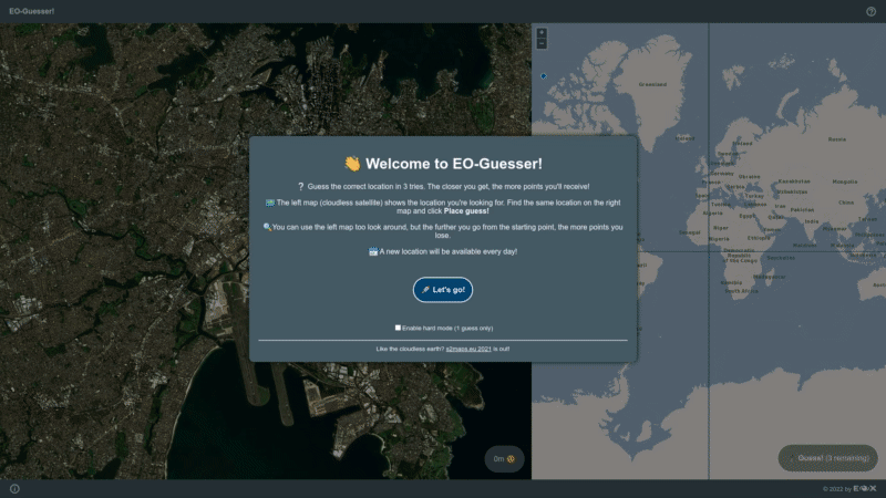
# EO-Guesser
Have you heard of GeoGuesser and are a fan of satellite imagery or the world from space? We have developed a neat new game and at EOX we are playing it with great enthusiasm since weeks.
If you want to try your luck or want to put your Earth Observation knowledge to test you have to try our EO-Guesser (opens new window). Being zoomed in on a random place on Earth just able to see the satellite map, can you guess where you are? How conversant are you with planet earth?
# Following next...
We will take part in this years Big Data from Space (opens new window) Conference in Vienna from November 6 to 9. If you want to connect personally, look out for EOX staff.
For more information download our EOxCludless brochure.
Finally, if you are looking for a nice screensaver to watch while on a coffee break click the "Tour" button at the bottom left of https://s2maps.eu (opens new window) and enjoy the ride. Also please note that our maps are free to use non commercially with proper attribution. If you aim to use our maps in your business please head to https://cloudless.eox.at (opens new window) or contact us directly via cloudless@eox.at.
# License
The 2016 version is provided for free under the Creative Commons Attribution 4.0 International Public License (opens new window) (CC BY 4.0), the 2018 - 2022 versions under Creative Commons Attribution-NonCommercial-ShareAlike 4.0 International Public License (opens new window) (CC BY-NS-SA 4.0). The required attribution is "Sentinel-2 cloudless - https://s2maps.eu (opens new window) by EOX IT Services GmbH (opens new window) (Contains modified Copernicus Sentinel data 2016 & 2017)" for 2016, "Sentinel-2 cloudless - https://s2maps.eu (opens new window) by EOX IT Services GmbH (opens new window) (Contains modified Copernicus Sentinel data 2017 & 2018)" for 2018, and "[Sentinel-2 cloudless - https://s2maps.eu) by EOX IT Services GmbH (opens new window) (Contains modified Copernicus Sentinel data 2019)" for 2019, "Sentinel-2 cloudless - https://s2maps.eu (opens new window) by EOX IT Services GmbH (opens new window) (Contains modified Copernicus Sentinel data 2020)" for 2020, "Sentinel-2 cloudless - https://s2maps.eu (opens new window) by EOX IT Services GmbH (opens new window) (Contains modified Copernicus Sentinel data 2021) for 2021" and "Sentinel-2 cloudless - https://s2maps.eu (opens new window) by EOX IT Services GmbH (opens new window) (Contains modified Copernicus Sentinel data 2022)" for 2022 respectively. It shall include the links as given here in on-line usage.
For commercial usage we offer the data (opens new window) under the EOX Commercial Attribution-RestrictedUse 1.1 License (opens new window) which is based on CC BY. The main change over CC BY is that EOX reserves the right to provide the data with this license. You're entirely free to use it in your services and products, you just can't transfer this license to your users. Usage examples include a WMTS you provide under your name or a product you sell that bundles the data for offline usage.
The EOX WMTS (opens new window) and EOX WMS (opens new window) are free and open to use for non-commercial applications given that when publishing the corresponding attribution (opens new window) is provided in the publication.
Miriam Mabeya, EOX IT Services GmbH Email: miriam.mabeya@eox.at
Petr Ševčík, EOX IT Services GmbH Email: petr.sevcik@eox.at
Joachim Ungar, EOX IT Services GmbH Email: joachim.ungar@eox.at
Contains Modified Copernicus Sentinel-2 Data 2016, 2017, 2019, 2020, 2021 and 2022.